Availability is not tracked here yet
The site details and map below come from the public Recreation.gov record and are accurate. For current dates and to book, go to Recreation.gov.
About Jack Creek Campground (WY)
Overview
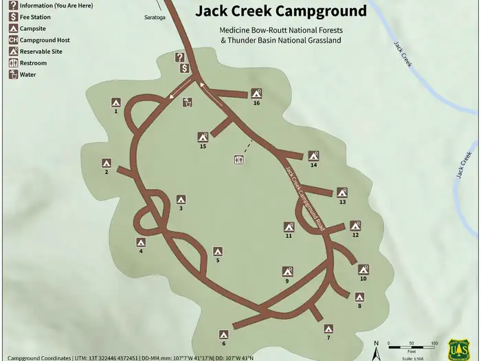
A campground in the Sierra Madre Range that sees medium use in the summer and fall. Facilities include 16 campsites, 4 are pull-through sites, picnic tables, fire rings, vault toilets, and water. The campground has a 14 day stay limit. Jack Creek Guard Station and Jack Creek Crew Quarters are nearby. This campground has primitive roads in the area for OHV riding. Both motorized and non-motorized portions of the Continental Divide National Scenic Trail are also in the vacinity. Trash Service is NOT Provided
Recreation
The Snowy Range offers endless recreational activities for any kind of visitor. Specifically, the Snowy Range contains a network of hiking trails suitable for day hiking and for extended, backcountry trips. Additionally, Streams and over 100 lakes in the area provide a variety of challenging recreational-fishing opportunities in the area. Popular attractions near this campground include Silver Lake, Lake Marie Falls, Mirror Lake, Medicine Bow Peak Trail, French Creek Canyon Trail and Miners Cabin Trail. Winter activities in the area include snowshoeing and skiing.
Mountain Biking
Areas for Mountain Biking at Snowy Range Area
• Bow River Campground
• Deep Creek Campground
• French Creek Campground
• French Creek Canyon Trail
• Keystone Cabins
• Lake Owen Trailhead
• Little Brooklyn Guard Station
• Little Laramie Trailhead
• North Fork Campground
• Pinkham Mountain Trailhead
• Rock Creek Trailhead
• Sheep Lake Trailhead
• Snow Survey Cabin
• Spruce Mountain Fire Lookout
• Tie Hack Lower Trailhead
• Tie Hack Upper Trailhead
• Tipple Trail Trailhead
Mountain Climbing
Areas for Mountain Climbing at Snowy Range Area
• Lewis Lake Picnic Site
• Libby Lake Picnic Site
Day Hiking
Areas for Day Hiking at Snowy Range Area
• Brooklyn Lake Campground
• Brush Creek Trails
• Chimney Park Trailhead
• Corner Mountain Trailhead
• Crater Lake Trailhead
• Deep Creek Campground
• Deep Lake Trail
• Dipper Lake Trail
• French Creek Campground
• French Creek Canyon Trail
• Green Rock Parking Lot
• Green Rock Picnic Site
• Keystone Cabins
• Lake Owen Trailhead
• Lakes Trailhead
• Lewis Lake Picnic Site
• Libby Lake Picnic Site
• Little Brooklyn Guard Station
• Little Laramie Trailhead
• Meadow Falls Trailhead
• Miner's Cabin Trailhead
• North Fork Campground
• Platte River Wilderness
• Quealy Lake Trailhead
• Rock Creek Trailhead
• Routt Access Trailhead
• Ryan Park Campground
• Savage Run Wilderness
• Sheep Lake Trailhead
• Silver Lake Campground
• Silver Lake Trailhead
• Six Mile Trailhead
• Snow Survey Cabin
• South Brush Creek Campground
• Spruce Mountain Fire Lookout
• Sugarloaf Campground
• Tie Hack Lower Trailhead
• Tie Hack Upper Trailhead
• Tipple Trail Trailhead
• West Lake Marie
Backpacking
Areas for Backpacking at Snowy Range Area
• Crater Lake Trailhead
• Deep Lake Trail
• Dipper Lake Trail
• Lakes Trailhead
• Lewis Lake Picnic Site
• Libby Lake Picnic Site
• Platte River Wilderness
• Quealy Lake Trailhead
• Rock Creek Trailhead
• Savage Run Wilderness
• Sheep Lake Trailhead
• Six Mile Trailhead
Viewing Wildlife
Areas for Viewing Wildlife at Snowy Range Area
• Brooklyn Lake Campground
• Keystone Cabins
• Libby Flats Observation Site
• Little Brooklyn Guard Station
• Snow Survey Cabin
• Spruce Mountain Fire Lookout
• Tipple Trail Trailhead
Nearby Attractions
Welcome to Medicine Bow-Routt National Forests and Thunder Basin National Grassland! Visitor opportunities abound on almost 2.9 million acres of National Forest System lands.
The Medicine Bow and Routt National Forests provide year-round recreation opportunities for you. These activities include hiking, biking, camping, snowmobiling, skiing, horseback riding, OHV riding, fishing and hunting, just to name a few. Elevation ranges from 5,500 to 12,940 feet. Beautiful vistas await sightseers and photographers. The Thunder Basin National Grassland provides unique opportunities for recreation, including hiking, sightseeing, hunting, and fishing. Elevation on the national grassland ranges from 3,600 to 5,200 feet.
Getting there
From Saratoga, WY: travel west on Carbon County Road 500, approximately 16 miles to junction with County Road 405, stay left and travel 3 miles up to the Forest boundary. Road number now changes to Forest Road 452. Stay on Forest Road 452 for 5 miles to Jack Creek Campground.
View on Recreation.gov ↗ Get directions ↗
Photo gallery

FAQ
How do I get a reservation at Jack Creek Campground (WY)?
Online reservations for this facility, where offered, are made through Recreation.gov. Pick a site on the map to see its calendar, or set a free Campsite Sniper alert. You complete the reservation yourself on Recreation.gov.
Does Campsite Sniper book this campground for me?
No. Campsite Sniper sends alerts and direct Recreation.gov links. It never books, pays for, holds, hoards, or resells reservations.
How current is this availability data?
Campsite Sniper does not currently hold availability data for Jack Creek Campground (WY), so there is nothing to date here. That is a gap in coverage — it does not mean the facility is full or closed. Check Recreation.gov for current dates.
Which sites at Jack Creek Campground (WY) fit a 35-foot RV?
1 of the 1 site that support RV analysis has a recorded maximum of 35 ft or more; the longest recorded is 84 ft.
Stop refreshing. Let the app watch it.
Lakefront, hookups, your RV length, weekends only - set it as picky as you want.
We run paced availability checks for Jack Creek Campground (WY). One watch covers every matching online-reservable site.
When a match opens, you get a push with a Recreation.gov link so you can review and book it yourself.
Alerts monitor online-reservable inventory only; first-come, first-served sites are not included.