No detected openings were recorded in the last 90 days. Campsite Sniper monitors Surveyors Lookout continuously and will alert you if that changes.
Of the 10 tracked site-nights (Sep 18 – Sep 27, 2026): 10 reserved.
Currently fully reserved online
Load status
Sep 18 – Sep 27, 2026Of the 10 tracked site-nights (Sep 18 – Sep 27, 2026): 10 reserved.
Open dates by month
Sep 2026 – Sep 2026No month in range currently shows online availability. 0 open site-nights across the tracked window — all tracked site-nights are reserved.
Holiday windows
Sites open per night · of 1 cabin| Window | Night | Sites open | Status |
|---|---|---|---|
| Labor Day | SAT Sep 5 | 0 | None open |
| SUN Sep 6 | 0 | None open | |
| MON Sep 7 | 0 | None open |
Labor Day: no online availability on any tracked night.
About Surveyors Lookout
Overview
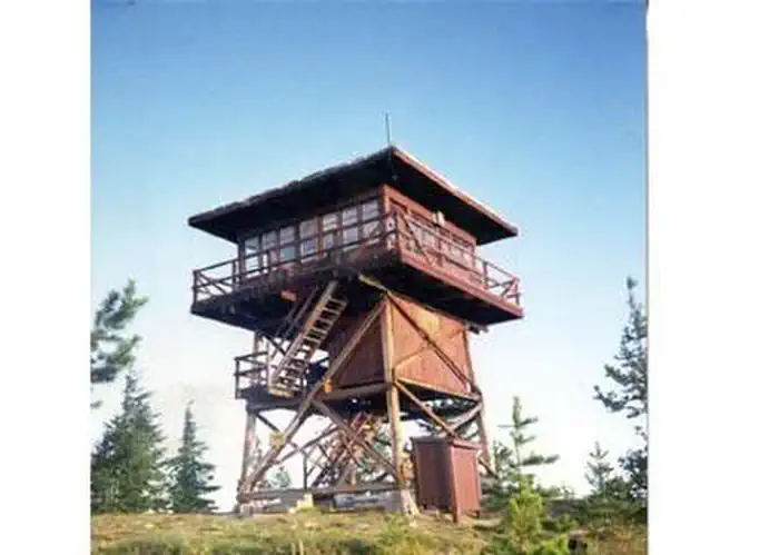
Located near the Mallard-Larkins Pioneer Area Attractions, Surveyors Lookout is perched atop a 30 foot tower, providing phenomenal views of Snow Peak and the surrounding mountains. The cabin is listed on the National Historic Register for Lookouts and offers visitors a unique camping experience in the Idaho Panhandle National Forest.
The original pole structure lookout was built in 1931 as part of a network of lookouts used to spot fires in the Upper St. Joe Country. The original lookout was replaced with the current treated timber structure in 1964.
Access to the lookout is via a rugged single-lane road with pullouts, and is not recommended for low clearance vehicles. Road may be slick when wet.
Recreation
The Mallard-Larkins Pioneer Area straddles the divide between the Little North Fork Clearwater River basins and the North Fork Clearwater River. This beautiful area attracts hikers and some technical rock climbers. Hunting and trout fishing are offered in designated areas.
From the lookout, there is access to Scribner Falls Trail #106 and nearby access to Surveyor's Ridge Trail #40, Horseshoe Loop Trail #141, and Northbound Creek Trail #111.
A scenic drive through the upper St. Joe country is an excellent way to take in the sights leading up to the lookout.
Facilities
Surveyors Lookout can accommodate up to four guests. Furnishings include a propane cook stove, heater and lights. A twin bed and two extra mattresses are provided, along with a chest with some drawers. A refrigerator is also available, but it is very small and unreliable. It is recommended that guests bring a cooler with ice as backup. Cooking pots and utensils are included.
No drinking water is available; guests should bring plenty of their own. An alternate option is to collect water from a spring located 1.4 miles down the access road. This water is non-potable and must be boiled or treated before consuming.
Items to pack include food, bedding, a first aid kit, dish soap, towels, toiletries and binoculars. If planning to collect water from a stream, water containers are needed. Guests are advised to bring warm clothes and blankets for cold evenings. Although a heater is provided, the lookout is not insulated so it remains cold.
Natural Features
Surveyors Lookout is located atop Surveyors Ridge at an elevation of 6,000 feet. The 30 foot tower overlooks the spectacular Mallard-Larkins Pioneer Area, which straddles the divide between the Little North Fork Clearwater River basins and the North Fork Clearwater River. Snow Peak, Middle Sister and Mallard Peak Lookouts are still standing and can be seen from Surveyors.
Getting there
From the St. Joe River Road (FH50) to Beaver Creek, drive 29 miles east of Avery to the junction of the Red Ives Road 218. Turn south (right) and drive 8 miles to the junction of Beaver Creek Road 303 (just past Beaver Creek Campground). Drive about 7.5 miles to Road 201. Turn south (left) toward Sawtooth Saddle. Drive 13 miles to access road to Surveyors Lookout (Road 395A). From St. Regis, take Little Joe Road 282 about 14.5 miles to the top of Gold Summit. Stay on the same road which changes names at the summit and becomes FH50. Travel about 12.5 miles to the junction of the Red Ives Road 218. Drive about 8 miles on the Red Ives Road to the junction of Beaver Creek Road 303 (just past Beaver Creek Campground). Drive about 7.5 miles to Road 201. Turn south (left) toward Sawtooth Saddle. Drive 13 miles to access road to Surveyors Lookout (Road 395A).
View on Recreation.gov ↗ Get directions ↗
FAQ
How do I get a reservation at Surveyors Lookout?
Reservations for Surveyors Lookout are made through Recreation.gov. All 10 tracked site-nights are currently reserved; a free alert catches the next detected opening. Pick a site on the map to see its calendar, or set a free Campsite Sniper alert. You complete the reservation yourself on Recreation.gov.
Does Campsite Sniper book this campground for me?
No. Campsite Sniper sends alerts and direct Recreation.gov links. It never books, pays for, holds, hoards, or resells reservations.
How current is this availability data?
Campsite Sniper re-checks public Recreation.gov availability for this facility every hour and republishes whenever anything changes. This facility's data last changed at Sep 18, 2026 14:17 UTC; an older timestamp means nothing has changed since that time, not that checking stopped. Always confirm final availability on Recreation.gov when you book.
Does Surveyors Lookout have online availability right now?
As of the Sep 18, 2026 snapshot, all 10 tracked site-nights are currently reserved. A free Campsite Sniper alert catches the next detected opening.
Stop refreshing. Let the app watch it.
Lakefront, hookups, your RV length, weekends only - set it as picky as you want.
We run paced availability checks for Surveyors Lookout. One watch covers every matching site.
When a match opens, you get a push with a Recreation.gov link so you can review and book it yourself.